On Lambs Knoll, South Mountain near Boonsboro MD
|
 |
Lambs Knoll near Boonsboro, Md.
|
|
Elevation
|
1,758 ft. (535.8 m)
|
Location
|
Location
|
Frederick County, Maryland
|
Range
|
South Mountain Blue Ridge Mountains
|
| Coordinates |
+39.448712 N -77.62749 W
|
Lambs Knoll is a peak of South Mountain on the border of Washington County and Frederick County in the state of Maryland, United States. The 1,758 feet (536 m) peak is the second tallest on South Mountain in Maryland behind Quirauk Mountain.
The peak is located to the south of Fox and Turner's Gaps, and marks the beginning of geographic change in South Mountain from a solitary narrow ridge to a broad highland plateau, as it nears the convergence with Catoctin Mountain. Lambs Knoll is also the site of a deactivated microwave relay station, that was used during the Cold War. The unit was encased in a 103 ft. tower, and known as the "Corkscrew” Site 7.
The Text Content on Page 1 of Morning Herald, July 25, 1977 is:
That silo isn’t for cattle

To the casual observer driving down Maryland Route 67 southwest of Boonsboro, the distant object atop of South Mountain looks like a farmer’s silo. Closer inspection would reveal that it is indeed a silo, but not the kind used to store cattle feed. This particular silo belongs to the US Navy and is one of at least three similar Top Secret Navy facilities in the Tri-State area. Two other silos are located atop mountain ridges in Pennsylvania and in West Virginia. Just what goes on inside the silos the Navy isn’t saying?
After repeated requests to the Navy for information on silos spokesman Ron Black gave this reply, “No information can be released its classified”.
According to residents of the area the Boonsboro silo was built sometime during the late 1960s. Like the others it is served by a narrow but a small road complete with guard rails. Although the Boonsboro silo is still in daily use the one located on Cross Mountain just inside the Pennsylvania state line north of Mercersburg was open earlier this year. The high chain link fence surrounding it has been ripped down and a heavy steel blast door leading into the silo was ajar recently. The silo is equipped with an elevator to each of its eight floors. Although much of the equipment inside has obviously been removed, much remains... Heavy air conditioning equipment, air filters and electrical panels are still in place. In an apparent effort to blast proof the equipment the panels are mounted on heavy springs with coiled wire lo take up movement. The silo apparently housed offices. On the ceilings are fluorescent lamps. The floors are tiled.
Whatever goes on inside the silos it is not related to the Alternate National Military Command Center near Blue Summit Pa.? Sources at the Pentagon responsible for The Rock say they do not know anything about the Navy silos.
And until the Navy decides to talk its mysterious silos will remain one of the government secrets in the area plus
In reality these silo's were part of a microwave network that was the backbone of communications for the Presidential Emergency Facilities.
The White House Communications Agency (WHCA) would play a key role in the implementation of Continuity of Government (COG) plan. The Continuity of Government is the principle of establishing defined procedures that allow a government to continue its essential operations in case of nuclear war or other catastrophic events. In 1954 a plan to implement emergency communications was developed and presented to the Secretary of Defense. A major element of this plan was an emergency relocation strategy which provided for the dispersal of essential elements of the Federal Government. This plan also addressed the necessary communications need by the President, and other Governmental agencies. Because little or no reliable communications were available in the emergency relocation areas, the Army Signal Corps was tasked with the planning, designing, engineering, installing and maintaining the communications support of this program.
These sites were constructed very quietly and actually hidden from the Public but in reality were in plain sight and visible from miles around, several of these Continuity of Government sites were built in Maryland, Pennsylvania, Virginia, West Virginia, and Washington, D.C., these sites were designed to house large numbers of federal officials in underground bunkers while the exposed concrete towers that housed sophisticated radio equipment kept communications open among the survivors, the military, and civilian populations. These were among the first relocation facilities built in the 1950s and early 1960s as federal planners conceived of and realized a Federal Relocation Arc extending outwards from Washington were key documents and people could be sheltered during and after a nuclear exchange.
The Federal Relocation Arc included above- and below-ground sites located within a 300-mile radius of the nation’s capital. These sites were administered through the Executive branch’s White House Military Office (WHMO), while the communications personnel were attached to the White House Communications Agency (WHCA). The Presidential Emergency Facilities (PEF) were literally holes in the ground, deep enough to withstand a nuclear blast and outfitted with elaborate communications equipment, funds to support the sites wound their way through a circuitous route in the Defense Department. All oversight for these facilities originated in the White House Military Office.
These sites in the Arc were the key to ensuring open lines of communications were built in a network that relied upon line-of-sight microwave technology, i.e., each transmitter and receiver had to have an unobstructed line-of-sight between its nearest neighbors for the network to be viable. These microwave hops were usually no more than fifty miles apart. “I’m assuming that when they did their studies they knew specifically where the main terminals were going to be and they looked for locations that they had line of sight, and they were all within forty miles of each other.”
Tower History and Purpose
Corkscrew was one of several presidential emergency facilities and related communications relay stations constructed in the early 1960s in the Washington, DC region. Construction of Corkscrew tower was completed in 1965. Named Corkscrew, the cylindrical tower and bunker was used as a potential relocation site for key members of the White House. The tower was part of a microwave network designed to provide reliable communications to the President of the United States and emergency communications in the event of a nuclear attack. The Microwave route connected Camp David and other key bodies of government directly to the White House.
The installation is no longer in service as a presidential shelter, and is now used by the Federal Aviation Administration. The FAA has altered the exterior (and, presumably, the interior) of the facility for its purposes. These alterations include the addition of a self-supporting steel lattice tower supporting a large high-frequency (shortwave) rotating log-periodic antenna for backup radio communications. The FAA's most recent construction project included adding and replacing several surface structures and converting the grass helicopter landing zone into an asphalt-paved parking lot.
The FAA compound is a restricted area and is protected by security personnel and systems. Visitors are not admitted unless on official business.
For at least some it’s operational life, the PEF shared the mountaintop with two unrelated facilities: an AT&T microwave relay station and a fire-lookout tower. The AT&T facility was made obsolete by fiber-optic cables and has been demolished. The fire tower was converted to a radio tower serving multiple Maryland state and local government agencies. That tower, which was in very poor condition, has been replaced by a modern tower and building performing the same function.
 |
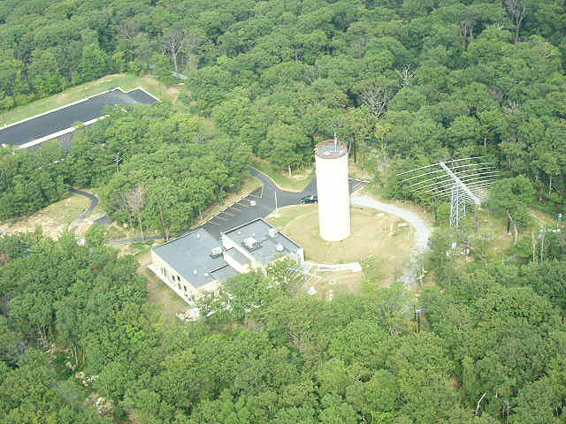
Aerial View of Corkscrew
|
This
annotated image shows the installations on Lambs Knoll as of August 2006.
Cross Section View of Tower


Lots of memories.
ReplyDeletemicrowave repair 1963-65 part of turn-up crew. anybody out there from that era?
DeleteI was just inside recently for some repair work. I'm not from that era.
Deletecan you elaborate if its not sensitive? I've seen the site and read some old stories about it. Love the one about it being a missile silo. Also the one about a metal room in the woods covering a submarine type hatch. I'm a Cold War technology buff and lots of old retired or repurposed structures in the Frederick, Hagerstown, and Southern PA area.
ReplyDeleteWonderful website. You mention that Corkscrew has restricted access. But do you know if it visible from outside the perimeter of the facility? How close can one get to the tower? Please let me know. Many thanks.
ReplyDeleteOne can walk up the road visible near the decommissioned AT&T tower & state-local government tower.
DeleteWish you could elaborate on what you saw and if the site is still functional? Lots of memories over a 20 year career that included many visits to this facility, and as the Camp David WHCA Commander, I was responsible at one time for everything from utilities, snow removal, staffing, operations, and maintenance 24/7.
ReplyDeletePerhaps you should send me an email at johncross910@gmail.com
Delete